
Make a donation
Gear up for your next adventure:
As an Amazon Associate, this site earns from qualifying purchases at no extra cost to you.
Santa Ana Pueblo topographic map
Click on the map to display elevation.
Make a donation
Gear up for your next adventure:
As an Amazon Associate, this site earns from qualifying purchases at no extra cost to you.
About this map
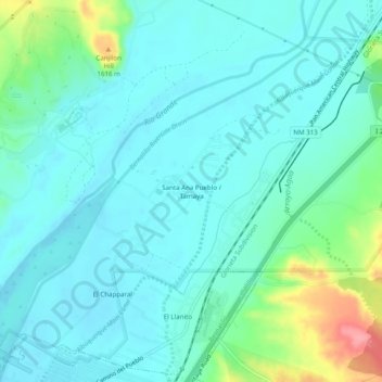
Name: Santa Ana Pueblo topographic map, elevation, terrain.
Average elevation: 5,112 ft
Minimum elevation: 5,046 ft
Maximum elevation: 5,374 ft
Sandoval County trails, hiking, mountain biking, running and outdoor activities
Make a donation
Gear up for your next adventure:
As an Amazon Associate, this site earns from qualifying purchases at no extra cost to you.
Other topographic maps
Click on a map to view its topography, its elevation and its terrain.
Make a donation
Gear up for your next adventure:
As an Amazon Associate, this site earns from qualifying purchases at no extra cost to you.
Bandelier National Monument
United States > New Mexico > Sandoval County
The monument is 50 square miles (130 km2) of the Pajarito Plateau, on the slopes of the Jemez volcanic field in the Jemez Mountains. Over 70% of the monument is wilderness, with over one mile of elevation change, from about 5,000 feet (1,500 m) along the Rio Grande to over 10,000 feet (3,000 m) at the peak of…
Average elevation: 6,988 ft
Kasha-Katuwe Tent Rocks National Monument
United States > New Mexico > Sandoval County
Average elevation: 6,076 ft
Make a donation
Gear up for your next adventure:
As an Amazon Associate, this site earns from qualifying purchases at no extra cost to you.
San Felipe Pueblo
United States > New Mexico > Sandoval County > San Felipe Pueblo
Average elevation: 5,381 ft