Geolocate

Scipio topographic map

Click on the map to display elevation.

About this map

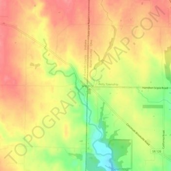
Name: Scipio topographic map, elevation, terrain.

Location: Scipio, Franklin County, Indiana, United States (39.37200 -84.83829 39.41200 -84.79829)

Average elevation: 896 ft

Minimum elevation: 735 ft

Maximum elevation: 991 ft

Franklin County trails, hiking, mountain biking, running and outdoor activities

Other topographic maps

Click on a map to view its topography, its elevation and its terrain.

Oldenburg

United States > Indiana > Franklin County

Average elevation: 945 ft

Mount Carmel

United States > Indiana > Franklin County

Average elevation: 1,007 ft

Gear up for your next adventure:

🎒Gear Packing Cubes - Organize your backpack efficiently
🌎3D Topographic Globes - Raised relief globes for a tactile understanding of geography
🔋Solar Power Banks - Keep your GPS and phone charged in remote wilderness areas
🎒Outdoor Daypacks - Lightweight backpacks designed for carrying maps and essential gear
📷Action Cameras - Rugged cameras to document your journeys across rugged terrain

As an Amazon Associate, this site earns from qualifying purchases at no extra cost to you.