Geolocate

Regal topographic map

Click on the map to display elevation.

About this map

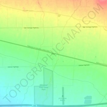
Name: Regal topographic map, elevation, terrain.

Location: Regal, Kittitas County, Washington, 98934, United States (46.97013 -120.48701 47.01013 -120.44701)

Average elevation: 1,611 ft

Minimum elevation: 1,512 ft

Maximum elevation: 1,745 ft

Kittitas County trails, hiking, mountain biking, running and outdoor activities

Other topographic maps

Click on a map to view its topography, its elevation and its terrain.

Rachel Lake

United States > Washington > Kittitas County

Average elevation: 4,610 ft

The Ganges

United States > Washington > Kittitas County > Ellensburg

Average elevation: 1,601 ft

South Cle Elum

United States > Washington > Kittitas County

Average elevation: 1,978 ft

Gear up for your next adventure:

🗃️Trail First Aid Kit - Essential kit for outdoor injuries and emergencies
🧭Compass with Lanyard - Easy‑carry compass for navigation
🪶Wildlife Field Guides - Learn animal tracking and species ID
☀️Outdoor Sunscreen - High protection sunscreen for outdoor activities
🎁Geography Themed Gifts - Unique gift ideas for map lovers and geography enthusiasts

As an Amazon Associate, this site earns from qualifying purchases at no extra cost to you.