
Make a donation
Gear up for your next adventure:
As an Amazon Associate, this site earns from qualifying purchases at no extra cost to you.
Schwabenrod topographic map
Click on the map to display elevation.
Make a donation
Gear up for your next adventure:
As an Amazon Associate, this site earns from qualifying purchases at no extra cost to you.
Schwabenrod
Die Statistisch-topographisch-historische Beschreibung des Großherzogthums Hessen berichtet 1830 über Schwabenrod.
Make a donation
Gear up for your next adventure:
As an Amazon Associate, this site earns from qualifying purchases at no extra cost to you.
About this map
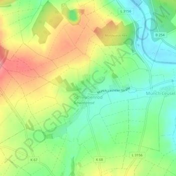
Name: Schwabenrod topographic map, elevation, terrain.
Location: Schwabenrod, Alsfeld, Vogelsbergkreis, Hessen, Deutschland (50.77018 9.23676 50.79782 9.27049)
Average elevation: 899 ft
Minimum elevation: 748 ft
Maximum elevation: 1,099 ft
Make a donation
Gear up for your next adventure:
As an Amazon Associate, this site earns from qualifying purchases at no extra cost to you.
Other topographic maps
Click on a map to view its topography, its elevation and its terrain.