Geolocate

Hanover topographic map

Click on the map to display elevation.

About this map

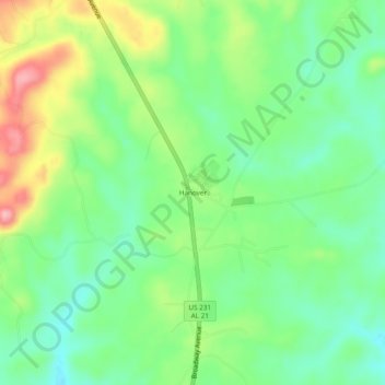
Name: Hanover topographic map, elevation, terrain.

Location: Hanover, Coosa County, Alabama, United States (32.98484 -86.22247 33.02484 -86.18247)

Average elevation: 764 ft

Minimum elevation: 604 ft

Maximum elevation: 1,043 ft

Coosa County trails, hiking, mountain biking, running and outdoor activities

Other topographic maps

Click on a map to view its topography, its elevation and its terrain.

Goodwater

United States > Alabama > Coosa County

Average elevation: 823 ft

Kellyton

United States > Alabama > Coosa County

Average elevation: 738 ft

Rockford

United States > Alabama > Coosa County

Average elevation: 725 ft

Gear up for your next adventure:

🪓Survival Multi‑Tool - Versatile tool for camp and trail tasks
🧦Hiking Socks - Comfortable socks to prevent blisters on long hikes
🧦Merino Wool Socks - Moisture-wicking, blister-preventing socks for long treks
🧯Portable Fire Pit - Compact fire pit for camping spots
🪶Camp Gear Gift Set - Perfect gift bundle for outdoor fans

As an Amazon Associate, this site earns from qualifying purchases at no extra cost to you.