
Angul topographic map
Click on the map to display elevation.
Angul
Angul (also known as Anugul) is a town and a municipality and the headquarters of Angul district in the state of Odisha, India. Angul has an average elevation of 195 m (640 ft) above sea level. The total geographical area of the district is 6232 km2. From the point of view of area, it stands 11th among the 30 Districts of Odisha.
About this map
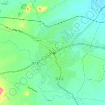
Name: Angul topographic map, elevation, terrain.
Location: Angul, Anugul, Angul District, Odisha, 759122, India (20.79824 85.05739 20.87824 85.13739)
Average elevation: 397 ft
Minimum elevation: 282 ft
Maximum elevation: 778 ft