Geolocate

Yarrow topographic map

Click on the map to display elevation.

About this map

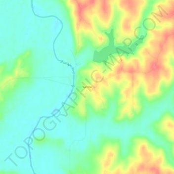
Name: Yarrow topographic map, elevation, terrain.

Location: Yarrow, Adair County, Missouri, United States (40.07392 -92.70047 40.11392 -92.66047)

Average elevation: 804 ft

Minimum elevation: 722 ft

Maximum elevation: 935 ft

Adair County trails, hiking, mountain biking, running and outdoor activities

Other topographic maps

Click on a map to view its topography, its elevation and its terrain.

Brashear

United States > Missouri > Adair County

Average elevation: 843 ft

Novinger

United States > Missouri > Adair County

Average elevation: 797 ft

Gibbs

United States > Missouri > Adair County

Average elevation: 896 ft

Gear up for your next adventure:

🥘Titanium Cookware - Durable, featherlight pots and pans for backpacking
🧭Outdoor Navigation Book - Learn advanced navigation skills
🧢Sun Protection Hats - Wide-brimmed and UPF-rated hats for high-altitude sun safety
👓Polarized Sunglasses - Outdoor sunglasses for glare reduction
🌐World Map Poster - Decorative world maps with topographic info

As an Amazon Associate, this site earns from qualifying purchases at no extra cost to you.