Geolocate

Comfort topographic map

Click on the map to display elevation.

About this map

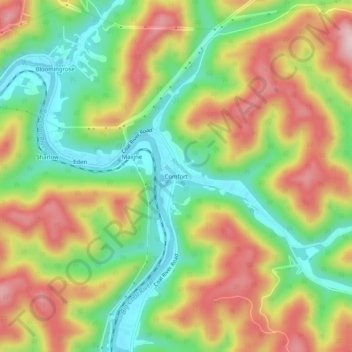
Name: Comfort topographic map, elevation, terrain.

Location: Comfort, Boone County, West Virginia, 25049, United States (38.11038 -81.63567 38.15038 -81.59567)

Average elevation: 1,086 ft

Minimum elevation: 646 ft

Maximum elevation: 1,598 ft

Boone County trails, hiking, mountain biking, running and outdoor activities

Other topographic maps

Click on a map to view its topography, its elevation and its terrain.

Whitesville

United States > West Virginia > Boone County

Average elevation: 1,352 ft

Madison

United States > West Virginia > Boone County

Average elevation: 1,066 ft

Danville

United States > West Virginia > Boone County

Average elevation: 919 ft

Sylvester

United States > West Virginia > Boone County

Average elevation: 1,266 ft

Gear up for your next adventure:

🧭Hiking Compass - Precision compass for reliable navigation in the wilderness
🧺Microfiber Travel Towels - Compact and fast-drying towels for trail use
🥩Freeze-Dried Meals - Nutritious and lightweight food for remote expeditions
Camping Coffee Makers - Enjoy premium coffee at the summit or campsite
🛡️Bear Spray Outdoor - Protection in bear country hikes

As an Amazon Associate, this site earns from qualifying purchases at no extra cost to you.