
Thank you for supporting this site ❤️
Make a donation
Make a donation
Gear up for your next adventure:
As an Amazon Associate, this site earns from qualifying purchases at no extra cost to you.
Estorninos topographic map
Click on the map to display elevation.
Thank you for supporting this site ❤️
Make a donation
Make a donation
Gear up for your next adventure:
As an Amazon Associate, this site earns from qualifying purchases at no extra cost to you.
About this map
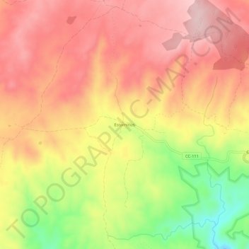
Name: Estorninos topographic map, elevation, terrain.
Location: Estorninos, Alcántara, Cáceres, Extremadura, 10991, Spain (39.72034 -6.95304 39.76034 -6.91304)
Average elevation: 1,024 ft
Minimum elevation: 548 ft
Maximum elevation: 1,316 ft
Thank you for supporting this site ❤️
Make a donation
Make a donation
Gear up for your next adventure:
As an Amazon Associate, this site earns from qualifying purchases at no extra cost to you.