
Make a donation
Gear up for your next adventure:
As an Amazon Associate, this site earns from qualifying purchases at no extra cost to you.
Walsheim topographic map
Click on the map to display elevation.
Make a donation
Gear up for your next adventure:
As an Amazon Associate, this site earns from qualifying purchases at no extra cost to you.
About this map
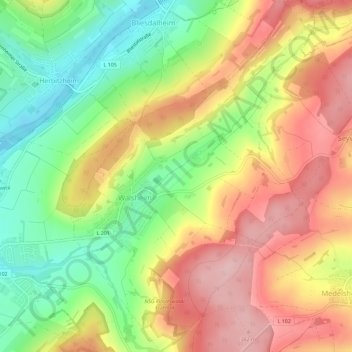
Name: Walsheim topographic map, elevation, terrain.
Location: Walsheim, Gersheim, Saarpfalz-Kreis, Saarland, Deutschland (49.13810 7.22323 49.17578 7.26271)
Average elevation: 974 ft
Minimum elevation: 673 ft
Maximum elevation: 1,266 ft
Make a donation
Gear up for your next adventure:
As an Amazon Associate, this site earns from qualifying purchases at no extra cost to you.
Other topographic maps
Click on a map to view its topography, its elevation and its terrain.
Südlicher Bliesgau/Auf der Lohe
Deutschland > Saarland > Saarpfalz-Kreis > Gersheim
Das rund 1575 ha große Gebiet wurde mit Verordnung vom 26. März 2004 unter der Kenn-Nummer NSG-108 unter Naturschutz gestellt. Es umfasst Hangflächen und Höhenzüge westlich der Blies.
Average elevation: 984 ft