Geolocate

Badarpur topographic map

Click on the map to display elevation.

About this map

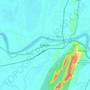
Name: Badarpur topographic map, elevation, terrain.

Location: Badarpur, Karimganj, Assam, 788805, India (24.83113 92.51852 24.91113 92.59852)

Average elevation: 89 ft

Minimum elevation: 30 ft

Maximum elevation: 541 ft

Gear up for your next adventure:

🔭Stargazing Telescopes - Perfect for camping in low-light pollution areas shown on maps
📱Solar Portable Charger - Solar power bank for charging devices off‑grid
📡GPS Antenna Upgrade - Enhance GPS reception in remote terrain
🪄Magnetic Compass - Accurate compass for navigation
Solar GPS Watches - Advanced multisport watches with built-in topographic maps

As an Amazon Associate, this site earns from qualifying purchases at no extra cost to you.