
Thank you for supporting this site ❤️
Make a donation
Make a donation
Gear up for your next adventure:
As an Amazon Associate, this site earns from qualifying purchases at no extra cost to you.
Fontanales topographic map
Click on the map to display elevation.
Thank you for supporting this site ❤️
Make a donation
Make a donation
Gear up for your next adventure:
As an Amazon Associate, this site earns from qualifying purchases at no extra cost to you.
About this map
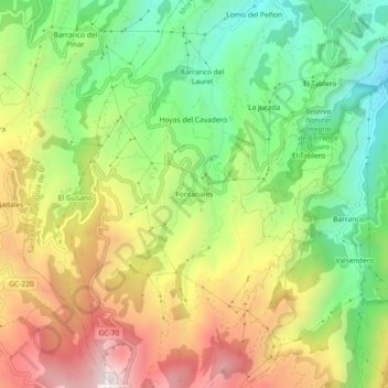
Name: Fontanales topographic map, elevation, terrain.
Location: Fontanales, Moya, Las Palmas, Canarias, 35457, España (28.03725 -15.62824 28.07725 -15.58824)
Average elevation: 3,448 ft
Minimum elevation: 2,103 ft
Maximum elevation: 5,138 ft
Thank you for supporting this site ❤️
Make a donation
Make a donation
Gear up for your next adventure:
As an Amazon Associate, this site earns from qualifying purchases at no extra cost to you.