
Thank you for supporting this site ❤️
Make a donation
Make a donation
Gear up for your next adventure:
As an Amazon Associate, this site earns from qualifying purchases at no extra cost to you.
Deloraine topographic map
Click on the map to display elevation.
Thank you for supporting this site ❤️
Make a donation
Make a donation
Gear up for your next adventure:
As an Amazon Associate, this site earns from qualifying purchases at no extra cost to you.
About this map
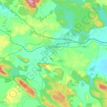
Name: Deloraine topographic map, elevation, terrain.
Location: Deloraine, Meander Valley, Tasmania, 7304, Australia (-41.59947 146.58237 -41.46731 146.72923)
Average elevation: 899 ft
Minimum elevation: 646 ft
Maximum elevation: 1,634 ft
Thank you for supporting this site ❤️
Make a donation
Make a donation
Gear up for your next adventure:
As an Amazon Associate, this site earns from qualifying purchases at no extra cost to you.