
Make a donation
Gear up for your next adventure:
As an Amazon Associate, this site earns from qualifying purchases at no extra cost to you.
Atlixco topographic map
Click on the map to display elevation.
Make a donation
Gear up for your next adventure:
As an Amazon Associate, this site earns from qualifying purchases at no extra cost to you.
About this map
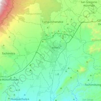
Name: Atlixco topographic map, elevation, terrain.
Location: Atlixco, Puebla, México (18.80210 -98.59356 19.00053 -98.30749)
Average elevation: 6,621 ft
Minimum elevation: 4,928 ft
Maximum elevation: 13,087 ft
Make a donation
Gear up for your next adventure:
As an Amazon Associate, this site earns from qualifying purchases at no extra cost to you.
Other topographic maps
Click on a map to view its topography, its elevation and its terrain.
San Agustín los Molinos
México > Puebla > Atlixco > Emiliano Zapata los Molinos
Average elevation: 6,434 ft
Make a donation
Gear up for your next adventure:
As an Amazon Associate, this site earns from qualifying purchases at no extra cost to you.
Make a donation
Gear up for your next adventure:
As an Amazon Associate, this site earns from qualifying purchases at no extra cost to you.
San Agustín los Molinos
México > Puebla > Atlixco > Emiliano Zapata los Molinos
Average elevation: 6,434 ft
Make a donation
Gear up for your next adventure:
As an Amazon Associate, this site earns from qualifying purchases at no extra cost to you.