Geolocate

St. Henry topographic map

Click on the map to display elevation.

About this map

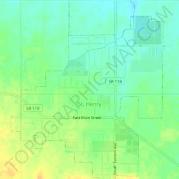
Name: St. Henry topographic map, elevation, terrain.

Location: St. Henry, Mercer County, Ohio, United States (40.40764 -84.65035 40.43602 -84.61890)

Average elevation: 965 ft

Minimum elevation: 925 ft

Maximum elevation: 1,014 ft

Mercer County trails, hiking, mountain biking, running and outdoor activities

Other topographic maps

Click on a map to view its topography, its elevation and its terrain.

Maria Stein

United States > Ohio > Mercer County

Average elevation: 968 ft

Gear up for your next adventure:

🎒Trekking Poles - Sturdy poles for balance and stability on rough terrain
👟Men's Trail Runners - Lightweight footwear for fast-paced exploration and light hiking
🪑Ultralight Camp Chairs - Portable seating for resting after a long day of mapping
🪶Fire Starter Kit - Reliable fire starter for survival and camping
🧦Hiking Socks - Comfortable socks to prevent blisters on long hikes

As an Amazon Associate, this site earns from qualifying purchases at no extra cost to you.