
Make a donation
Gear up for your next adventure:
As an Amazon Associate, this site earns from qualifying purchases at no extra cost to you.
Pembroke topographic map
Click on the map to display elevation.
Make a donation
Gear up for your next adventure:
As an Amazon Associate, this site earns from qualifying purchases at no extra cost to you.
Pembroke
According to the United States Census Bureau, the town has a total area of 22.8 square miles (59.1 km2), of which 22.6 square miles (58.6 km2) are land and 0.2 square miles (0.5 km2) are water, comprising 0.76% of the town. Pembroke is drained by the Merrimack River and its tributaries, the Suncook and the Soucook. The Merrimack River forms the southwest border of the town, the Soucook forms the northwest border, and the Suncook forms the southeast border. The highest point in town, Plausawa Hill, elevation 1,000 feet (305 m) above sea level, is in the north.
Make a donation
Gear up for your next adventure:
As an Amazon Associate, this site earns from qualifying purchases at no extra cost to you.
About this map
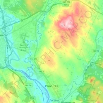
Name: Pembroke topographic map, elevation, terrain.
Average elevation: 430 ft
Minimum elevation: 177 ft
Maximum elevation: 1,001 ft
Merrimack County trails, hiking, mountain biking, running and outdoor activities
Make a donation
Gear up for your next adventure:
As an Amazon Associate, this site earns from qualifying purchases at no extra cost to you.
Other topographic maps
Click on a map to view its topography, its elevation and its terrain.
Kelleys Corner
United States > New Hampshire > Merrimack County > Chichester
Average elevation: 518 ft
Make a donation
Gear up for your next adventure:
As an Amazon Associate, this site earns from qualifying purchases at no extra cost to you.
Newbury
United States > New Hampshire > Merrimack County > Newbury > Newbury
According to the United States Census Bureau, the town has a total area of 38.1 square miles (98.7 km2), of which 35.8 square miles (92.8 km2) are land and 2.3 square miles (5.9 km2) are water, comprising 5.94% of the town. Mount Sunapee, the highest point in town, has an elevation of 2,726 feet (831 m) above…
Average elevation: 1,496 ft
Make a donation
Gear up for your next adventure:
As an Amazon Associate, this site earns from qualifying purchases at no extra cost to you.
North Pembroke
United States > New Hampshire > Merrimack County > Pembroke > North Pembroke
Average elevation: 650 ft
Ragged Mountain
United States > New Hampshire > Merrimack County > Danbury
Average elevation: 1,627 ft
Salisbury Heights
United States > New Hampshire > Merrimack County > Salisbury > Salisbury Heights
Average elevation: 804 ft
Make a donation
Gear up for your next adventure:
As an Amazon Associate, this site earns from qualifying purchases at no extra cost to you.