
Thank you for supporting this site ❤️
Make a donation
Make a donation
Gear up for your next adventure:
As an Amazon Associate, this site earns from qualifying purchases at no extra cost to you.
Gonzales Suarez topographic map
Click on the map to display elevation.
Thank you for supporting this site ❤️
Make a donation
Make a donation
Gear up for your next adventure:
As an Amazon Associate, this site earns from qualifying purchases at no extra cost to you.
About this map
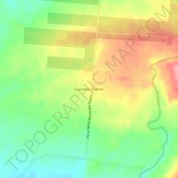
Name: Gonzales Suarez topographic map, elevation, terrain.
Location: Gonzales Suarez, Valencia, Los Ríos, Ecuador (-0.70478 -79.25391 -0.66478 -79.21391)
Average elevation: 1,129 ft
Minimum elevation: 938 ft
Maximum elevation: 1,355 ft
Thank you for supporting this site ❤️
Make a donation
Make a donation
Gear up for your next adventure:
As an Amazon Associate, this site earns from qualifying purchases at no extra cost to you.
Other topographic maps
Click on a map to view its topography, its elevation and its terrain.
Parque Central de la Parroquia la Nueva Unión
Ecuador > Los Ríos > Valencia > Valencia > La Union > Nueva Unión
Average elevation: 390 ft