
Make a donation
Gear up for your next adventure:
As an Amazon Associate, this site earns from qualifying purchases at no extra cost to you.
Figueras topographic map
Click on the map to display elevation.
Make a donation
Gear up for your next adventure:
As an Amazon Associate, this site earns from qualifying purchases at no extra cost to you.
Figueras
El relieve del municipio es predominantemente llano, al situarse en plena llanura del Ampurdán. La altitud oscila entre los 136 metros al noroeste y los 10 metros a orillas del curso de agua conocido como El Manol, situado al este. El casco histórico se alza a 44 metros sobre el nivel del mar.
Make a donation
Gear up for your next adventure:
As an Amazon Associate, this site earns from qualifying purchases at no extra cost to you.
About this map
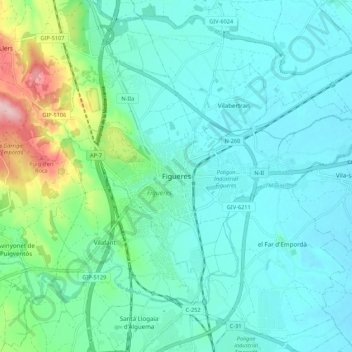
Name: Figueras topographic map, elevation, terrain.
Average elevation: 157 ft
Minimum elevation: 30 ft
Maximum elevation: 699 ft
Make a donation
Gear up for your next adventure:
As an Amazon Associate, this site earns from qualifying purchases at no extra cost to you.