
Make a donation
Gear up for your next adventure:
As an Amazon Associate, this site earns from qualifying purchases at no extra cost to you.
Fléron topographic map
Click on the map to display elevation.
Make a donation
Gear up for your next adventure:
As an Amazon Associate, this site earns from qualifying purchases at no extra cost to you.
Fléron
Fléron ligt op het Plateau van Herve op een hoogte van ongeveer 250 meter. Noordelijk hiervan begint de Ri du Moulin die in noordwestelijke richting naar de Maas vloeit. De omgeving is enigszins verstedelijkt, maar hier en daar zijn nog resten van het oorspronkelijke landschap aanwezig.
Make a donation
Gear up for your next adventure:
As an Amazon Associate, this site earns from qualifying purchases at no extra cost to you.
About this map
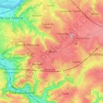
Name: Fléron topographic map, elevation, terrain.
Location: Fléron, Luik, Wallonië, 4620, België (50.57684 5.64322 50.65684 5.72322)
Average elevation: 643 ft
Minimum elevation: 180 ft
Maximum elevation: 1,043 ft
Make a donation
Gear up for your next adventure:
As an Amazon Associate, this site earns from qualifying purchases at no extra cost to you.