Geolocate

Borken topographic map

Click on the map to display elevation.

About this map

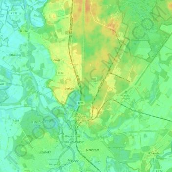
Name: Borken topographic map, elevation, terrain.

Location: Borken, Meppen, Landkreis Emsland, Lower Saxony, Germany (52.70755 7.23321 52.74374 7.35107)

Average elevation: 59 ft

Minimum elevation: 23 ft

Maximum elevation: 115 ft

Other topographic maps

Click on a map to view its topography, its elevation and its terrain.

Mühlenmoor

Germany > Lower Saxony > Landkreis Emsland > Meppen > Helte

Average elevation: 56 ft

Gear up for your next adventure:

🧣Merino Neck Gaiters - Multi-functional headwear for wind and sun protection
🧦Hiking Socks - Comfortable socks to prevent blisters on long hikes
🚪Portable Camp Chair - Foldable chair for comfort at camp
🧭Pro Hiking Compasses - High-accuracy liquid-filled compasses for topographic orientation
Camping Coffee Makers - Enjoy premium coffee at the summit or campsite

As an Amazon Associate, this site earns from qualifying purchases at no extra cost to you.