
Thank you for supporting this site ❤️
Make a donation
Make a donation
Gear up for your next adventure:
As an Amazon Associate, this site earns from qualifying purchases at no extra cost to you.
Sardinata topographic map
Click on the map to display elevation.
Thank you for supporting this site ❤️
Make a donation
Make a donation
Gear up for your next adventure:
As an Amazon Associate, this site earns from qualifying purchases at no extra cost to you.
About this map
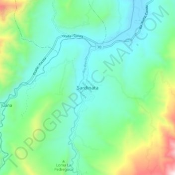
Name: Sardinata topographic map, elevation, terrain.
Location: Sardinata, Norte, Norte de Santander, Colombia (8.04410 -72.84007 8.12410 -72.76007)
Average elevation: 1,788 ft
Minimum elevation: 741 ft
Maximum elevation: 5,121 ft
Thank you for supporting this site ❤️
Make a donation
Make a donation
Gear up for your next adventure:
As an Amazon Associate, this site earns from qualifying purchases at no extra cost to you.
Other topographic maps
Click on a map to view its topography, its elevation and its terrain.
Corregimiento El Carmen
Colombia > Norte de Santander > Sardinata > Sardinata
Average elevation: 2,087 ft