Geolocate

Waterville topographic map

Click on the map to display elevation.

About this map

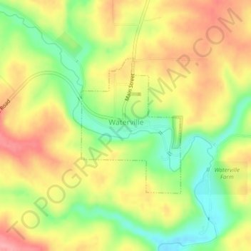
Name: Waterville topographic map, elevation, terrain.

Location: Waterville, Allamakee County, Iowa, United States (43.20000 -91.30421 43.21458 -91.28952)

Average elevation: 955 ft

Minimum elevation: 761 ft

Maximum elevation: 1,132 ft

Allamakee County trails, hiking, mountain biking, running and outdoor activities

Other topographic maps

Click on a map to view its topography, its elevation and its terrain.

Elon

United States > Iowa > Allamakee County

Average elevation: 1,099 ft

Dorchester

United States > Iowa > Allamakee County

Average elevation: 984 ft

Gear up for your next adventure:

🪶Fire Starter Kit - Reliable fire starter for survival and camping
🛠️Backpacking Tool Kit - Essential toolkit for outdoor repairs
🪶Camp Gear Gift Set - Perfect gift bundle for outdoor fans
🧭Orienteering Set - Complete compass and map reading kit
🥩Freeze-Dried Meals - Nutritious and lightweight food for remote expeditions

As an Amazon Associate, this site earns from qualifying purchases at no extra cost to you.