Geolocate

Tulum topographic map

Click on the map to display elevation.

Tulum

Like most of the Yucatan Peninsula Tulum is entirely flat with a gentle slope towards the sea, so from west to east, the area never reaches an altitude higher than 25 metres (82 ft) above sea level. The municipality is 5 metres (16 ft) above sea level on average.

Wikipedia (CC-BY-SA 3.0)

About this map

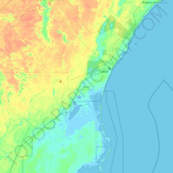
Name: Tulum topographic map, elevation, terrain.

Location: Tulum, Quintana Roo, Mexico (19.77730 -87.99507 20.51609 -87.30264)

Average elevation: 33 ft

Minimum elevation: -16 ft

Maximum elevation: 95 ft

Other topographic maps

Click on a map to view its topography, its elevation and its terrain.

Puerto Aventuras

Mexico > Quintana Roo

Average elevation: 13 ft

Solferino

Mexico > Quintana Roo > Lázaro Cárdenas

Average elevation: 33 ft

Mahahual

Mexico > Quintana Roo > Othón P. Blanco

Average elevation: 7 ft

Holbox

Mexico > Quintana Roo > Lázaro Cárdenas

Average elevation: 0 ft

Mahahual

Mexico > Quintana Roo > Othón P. Blanco

Average elevation: 7 ft

Akumal

Mexico > Quintana Roo

Average elevation: 7 ft

Isla Holbox

Mexico > Quintana Roo

Average elevation: 3 ft

Lagos del Sol

Mexico > Quintana Roo > Cancún

Average elevation: 13 ft

Tampak

Mexico > Quintana Roo > Felipe Carrillo Puerto

Average elevation: 92 ft

Cenote Mayan Blue

Mexico > Quintana Roo > Tulum

Average elevation: 10 ft

Gear up for your next adventure:

🧴Hand Sanitizer - Keep hands clean while hiking
📡Handheld GPS Device - Reliable handheld GPS for outdoor navigation
🔥Camping Stove - Portable stove for camping and backcountry cooking
🛌Ultralight Sleeping Bags - Compact down bags for cold nights in the wilderness
🧭Compass with Lanyard - Easy‑carry compass for navigation

As an Amazon Associate, this site earns from qualifying purchases at no extra cost to you.