
Make a donation
Gear up for your next adventure:
As an Amazon Associate, this site earns from qualifying purchases at no extra cost to you.
Fontana Lake topographic map
Click on the map to display elevation.
Make a donation
Gear up for your next adventure:
As an Amazon Associate, this site earns from qualifying purchases at no extra cost to you.
Fontana Lake
Fontana Lake provides the only access into the most remote areas of the National Park, unless visitors undertake a multi-day hike to get there. When the lake is at the normal summer level, a boat may be used to access remote trailheads such as Hazel Creek. From the observation tower on Kuwohi, on a clear day the lake can be seen nearly a mile below. While the maximum controlled elevation of the lake (top of dam gates) is 1,710 ft (520 m), the normal Summer surface elevation is 1,703 ft (519 m). NC 28 roughly parallels the southern shore of the lake, and US 19, between Bryson City and Wesser/Lauada, briefly skims an inlet at the extreme southeastern edge.
Make a donation
Gear up for your next adventure:
As an Amazon Associate, this site earns from qualifying purchases at no extra cost to you.
About this map
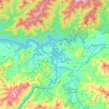
Name: Fontana Lake topographic map, elevation, terrain.
Location: Fontana Lake, Swain County, North Carolina, United States (35.33446 -83.80977 35.48456 -83.50520)
Average elevation: 2,644 ft
Minimum elevation: 1,631 ft
Maximum elevation: 5,246 ft
Swain County trails, hiking, mountain biking, running and outdoor activities
Make a donation
Gear up for your next adventure:
As an Amazon Associate, this site earns from qualifying purchases at no extra cost to you.
Other topographic maps
Click on a map to view its topography, its elevation and its terrain.
Kuwohi
United States > North Carolina > Swain County
At an elevation of 6,643 feet (2,025 m), it is the highest mountain in the Great Smoky Mountains National Park, the highest point in the state of Tennessee, and the highest point along the 2,192-mile (3,528 km) Appalachian Trail. It is also the third highest point in eastern mainland North America, after Mount…
Average elevation: 5,630 ft
Ravensford
United States > North Carolina > Swain County > Yellowhill Community
Average elevation: 2,530 ft
Make a donation
Gear up for your next adventure:
As an Amazon Associate, this site earns from qualifying purchases at no extra cost to you.
Make a donation
Gear up for your next adventure:
As an Amazon Associate, this site earns from qualifying purchases at no extra cost to you.
Make a donation
Gear up for your next adventure:
As an Amazon Associate, this site earns from qualifying purchases at no extra cost to you.
Fontana Dam
United States > North Carolina > Swain County
Fontana Dam is 2,365 feet (721 m) long and 480 feet (146 m) high, making it the tallest dam in the Eastern United States. The dam has a flood storage capacity of 513,965 acre-feet (633,966,000 m3), and the combined capacity of its three generators is 293.6 megawatts. Fontana Lake has 238 miles (383 km) of…
Average elevation: 1,722 ft
Cherokee
United States > North Carolina > Swain County > Yellowhill Community
Cherokee and its surrounding Qualla Boundary is in the very mountainous Swain and Jackson counties. The highest elevation is 6,643-foot (2,025 m) Clingman's Dome at the border with Tennessee. Clingman's Dome is the highest point in the Great Smoky Mountains National Park. The Oconaluftee River flows through…
Average elevation: 2,448 ft
Make a donation
Gear up for your next adventure:
As an Amazon Associate, this site earns from qualifying purchases at no extra cost to you.