
Thank you for supporting this site ❤️
Make a donation
Make a donation
Gear up for your next adventure:
As an Amazon Associate, this site earns from qualifying purchases at no extra cost to you.
Vidrà topographic map
Click on the map to display elevation.
Thank you for supporting this site ❤️
Make a donation
Make a donation
Gear up for your next adventure:
As an Amazon Associate, this site earns from qualifying purchases at no extra cost to you.
About this map
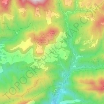
Name: Vidrà topographic map, elevation, terrain.
Location: Vidrà, Osona, Gerona, Catalonië, 17515, Spanje (42.10282 2.29068 42.14282 2.33068)
Average elevation: 3,353 ft
Minimum elevation: 2,457 ft
Maximum elevation: 4,478 ft
Thank you for supporting this site ❤️
Make a donation
Make a donation
Gear up for your next adventure:
As an Amazon Associate, this site earns from qualifying purchases at no extra cost to you.