
Peterson AFB Parade Grounds topographic map
Interactive map
Click on the map to display elevation.
About this map
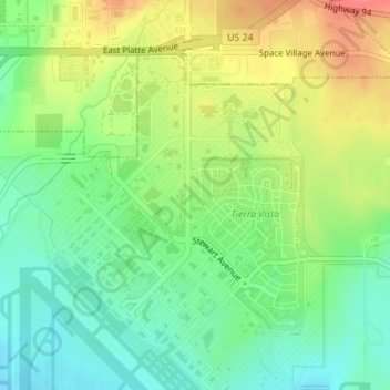
Name: Peterson AFB Parade Grounds topographic map, elevation, terrain.
Average elevation: 6,230 ft
Minimum elevation: 6,142 ft
Maximum elevation: 6,352 ft
Other topographic maps
Click on a map to view its topography, its elevation and its terrain.
Air Force Academy
United States > Colorado > El Paso County > Colorado Springs
Air Force Academy, Colorado Springs, El Paso County, Colorado, 80840, United States
Average elevation: 7,080 ft
Stratton Meadows
United States > Colorado > El Paso County > Colorado Springs
Stratton Meadows, Colorado Springs, El Paso County, Colorado, 80906, United States
Average elevation: 5,968 ft
Garden of the Gods
United States > Colorado > El Paso County > Colorado Springs
Garden of the Gods, Colorado Springs, El Paso County, Colorado, 80829, United States
Average elevation: 6,463 ft
Quail Lake
United States > Colorado > El Paso County > Colorado Springs
Quail Lake, Colorado Springs, El Paso County, Colorado, United States
Average elevation: 5,965 ft
Sleeping Giant
United States > Colorado > El Paso County > Colorado Springs
Sleeping Giant, Colorado Springs, El Paso County, Colorado, United States
Average elevation: 6,467 ft
North Cheyenne Cañon Park
United States > Colorado > El Paso County > Colorado Springs
North Cheyenne Cañon Park, Colorado Springs, El Paso County, Colorado, United States
Average elevation: 7,297 ft