Geolocate

Hudson topographic map

Click on the map to display elevation.

About this map

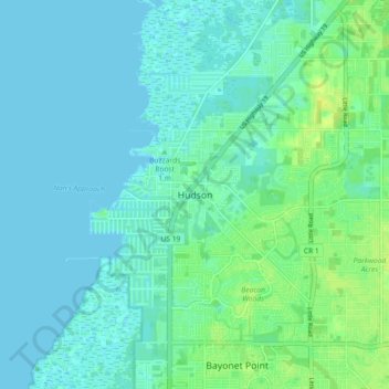
Name: Hudson topographic map, elevation, terrain.

Location: Hudson, Pasco County, Florida, 34667, United States (28.32177 -82.73328 28.40177 -82.65328)

Average elevation: 13 ft

Minimum elevation: -3 ft

Maximum elevation: 49 ft

Pasco County trails, hiking, mountain biking, running and outdoor activities

Other topographic maps

Click on a map to view its topography, its elevation and its terrain.

Shady Hills

United States > Florida > Pasco County

Average elevation: 59 ft

Moon Lake

United States > Florida > Pasco County > River Ridge

Average elevation: 39 ft

Odessa

United States > Florida > Pasco County

Average elevation: 56 ft

Gear up for your next adventure:

🧭Orienteering Set - Complete compass and map reading kit
📚USA Hiking Guide Books - Top trail guides and map books
🥘Titanium Cookware - Durable, featherlight pots and pans for backpacking
🦟Ultrasonic Repellers - Create a bug-free zone at your camp or rest stop
🔭Stargazing Telescopes - Perfect for camping in low-light pollution areas shown on maps

As an Amazon Associate, this site earns from qualifying purchases at no extra cost to you.