
Rishton topographic map
Click on the map to display elevation.
Rishton
Rishton is situated in an area of low moorland north east of Blackburn and north west of Accrington. Its elevation above sea level varies from 250 feet (76 m) in the east, where Norden Brook flows into the River Hyndburn, to 785 feet (239 m) on Rishton Height, north west of the town.
About this map
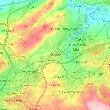
Name: Rishton topographic map, elevation, terrain.
Average elevation: 495 ft
Minimum elevation: 187 ft
Maximum elevation: 928 ft
Other topographic maps
Click on a map to view its topography, its elevation and its terrain.
Oswaldtwistle Moor
United Kingdom > England > Lancashire > Hyndburn > Green Haworth > Cocker Brook
Average elevation: 984 ft