
Carpa topographic map
Click on the map to display elevation.
About this map
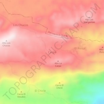
Name: Carpa topographic map, elevation, terrain.
Location: Carpa, Municipio Unión, Falcon State, Venezuela (10.78395 -69.23307 10.82395 -69.19307)
Average elevation: 2,651 ft
Minimum elevation: 1,286 ft
Maximum elevation: 3,323 ft
Other topographic maps
Click on a map to view its topography, its elevation and its terrain.
Morrocoy National Park
Venezuela > Falcon State > Municipio Silva
The park's bays, mangroves, cays and islands sit in the shadow of the Chichiriviche hills, with elevations up to around 250 m. At 285 m high, Chichiriviche Hill is the highest point in the park. It stands amid the surrounding coastal environment of Tertiary-period coral origin, belonging to the Capadare - Agua…
Average elevation: 33 ft