
Make a donation
Gear up for your next adventure:
As an Amazon Associate, this site earns from qualifying purchases at no extra cost to you.
Saar topographic map
Click on the map to display elevation.
Make a donation
Gear up for your next adventure:
As an Amazon Associate, this site earns from qualifying purchases at no extra cost to you.
About this map
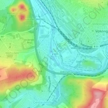
Name: Saar topographic map, elevation, terrain.
Average elevation: 709 ft
Minimum elevation: 574 ft
Maximum elevation: 1,007 ft
Make a donation
Gear up for your next adventure:
As an Amazon Associate, this site earns from qualifying purchases at no extra cost to you.
Other topographic maps
Click on a map to view its topography, its elevation and its terrain.
Fürstenhausen
Deutschland > Saarland > Regionalverband Saarbrücken > Völklingen
Average elevation: 751 ft
Ludweiler
Deutschland > Saarland > Regionalverband Saarbrücken > Völklingen
Fenne | Fürstenhausen | Geislautern | Heidstock | Lauterbach | Ludweiler | Luisenthal | Röchlinghöhe | Völklingen | Wehrden
Average elevation: 810 ft
Geislautern
Deutschland > Saarland > Regionalverband Saarbrücken > Völklingen
Fenne | Fürstenhausen | Geislautern | Heidstock | Lauterbach | Ludweiler | Luisenthal | Röchlinghöhe | Völklingen | Wehrden
Average elevation: 758 ft
Lauterbach
Deutschland > Saarland > Regionalverband Saarbrücken > Völklingen
Fenne | Fürstenhausen | Geislautern | Heidstock | Lauterbach | Ludweiler | Luisenthal | Röchlinghöhe | Völklingen | Wehrden
Average elevation: 830 ft
Make a donation
Gear up for your next adventure:
As an Amazon Associate, this site earns from qualifying purchases at no extra cost to you.