
Make a donation
Gear up for your next adventure:
As an Amazon Associate, this site earns from qualifying purchases at no extra cost to you.
La Guaira topographic map
Click on the map to display elevation.
Make a donation
Gear up for your next adventure:
As an Amazon Associate, this site earns from qualifying purchases at no extra cost to you.
About this map
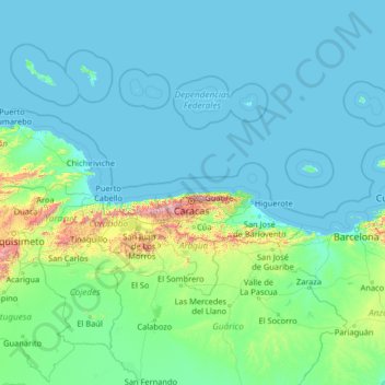
Name: La Guaira topographic map, elevation, terrain.
Location: La Guaira, Venezuela (8.01054 -69.49824 13.21054 -64.29824)
Average elevation: 381 ft
Minimum elevation: -3 ft
Maximum elevation: 8,497 ft
Make a donation
Gear up for your next adventure:
As an Amazon Associate, this site earns from qualifying purchases at no extra cost to you.
Other topographic maps
Click on a map to view its topography, its elevation and its terrain.
Villa Rosa
Venezuela > Anzoategui State > Municipio Simón Rodríguez > El Tigre
Average elevation: 922 ft
Anzoategui State
The vegetation of the Anzoátegui State is typical temperate. It is largely determined by altitude, climate and season of the year, where areas of snow-covered scrub, cujíes and small southern species alternate. It also has a tree called caderoms, this includes resistant or environmentally adapted varieties.
Average elevation: 512 ft
Make a donation
Gear up for your next adventure:
As an Amazon Associate, this site earns from qualifying purchases at no extra cost to you.
Lara State
Lara's topography consist of high plains and low, broken hills, with a relatively hot and dry climate. Lara depression is located at altitudes between 1,600 and 2,600 ft (487 to 792 m). Among the landscapes of moderate height, the pressures of Carora, Barquisimeto and Yaracuy stand out, while the Sierra de…
Average elevation: 2,133 ft