
Thank you for supporting this site ❤️
Make a donation
Make a donation
Gear up for your next adventure:
As an Amazon Associate, this site earns from qualifying purchases at no extra cost to you.
Koszęcin topographic map
Click on the map to display elevation.
Thank you for supporting this site ❤️
Make a donation
Make a donation
Gear up for your next adventure:
As an Amazon Associate, this site earns from qualifying purchases at no extra cost to you.
About this map
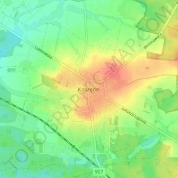
Name: Koszęcin topographic map, elevation, terrain.
Location: Koszęcin, gmina Koszęcin, Lubliniec County, 42-286, Poland (50.61592 18.82133 50.65592 18.86133)
Average elevation: 925 ft
Minimum elevation: 850 ft
Maximum elevation: 1,033 ft
Thank you for supporting this site ❤️
Make a donation
Make a donation
Gear up for your next adventure:
As an Amazon Associate, this site earns from qualifying purchases at no extra cost to you.