
Anand topographic map
Click on the map to display elevation.
Anand
Anand is located at 22°34′N 72°56′E / 22.57°N 72.93°E / 22.57; 72.93. It has an average elevation of 39 m (128 ft). The city has an area of 47.89 km2 (18.49 sq mi).
About this map
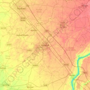
Name: Anand topographic map, elevation, terrain.
Location: Anand, Anand City Taluka, Anand, Gujarat, 388001, India (22.39866 72.80272 22.71866 73.12272)
Average elevation: 131 ft
Minimum elevation: 13 ft
Maximum elevation: 194 ft