Geolocate

King Island topographic map

Click on the map to display elevation.

About this map
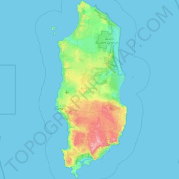
Name: King Island topographic map, elevation, terrain.

Location: King Island, Tasmania, 7256, Australia (-40.15799 143.83215 -39.57926 144.13822)

Average elevation: 46 ft

Minimum elevation: 0 ft

Maximum elevation: 522 ft

Other topographic maps

Click on a map to view its topography, its elevation and its terrain.
The Nut

Australia > Tasmania > Stanley

Average elevation: 26 ft

Cathedral Mountain

Australia > Tasmania

Average elevation: 3,255 ft

Rowlands Hill

Australia > Tasmania

Average elevation: 1,273 ft

Waterworks Reserve

Australia > Tasmania > Hobart

Average elevation: 787 ft

Bream Creek

Australia > Tasmania > Bream Creek

Average elevation: 115 ft

Cradle Mountain

Australia > Tasmania > Cradle Mountain

Average elevation: 3,753 ft

West Gawler River

Australia > Tasmania > Sprent > Gawler

Average elevation: 659 ft

Gear up for your next adventure:

🩳Quick‑Dry Hiking Shorts - Comfortable and quick‑dry shorts for summer hiking
🪑Portable Camp Table - Compact table for campsite meals
🦶Carbon Trekking Poles - Reduce knee impact on steep descents with ultra-light poles
🪶Wildlife Field Guides - Learn animal tracking and species ID
🌡️Portable Weather Meter - Track weather conditions on the trail

As an Amazon Associate, this site earns from qualifying purchases at no extra cost to you.