Geolocate

Mahim Bay topographic map

Click on the map to display elevation.

About this map

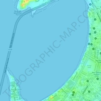
Name: Mahim Bay topographic map, elevation, terrain.

Location: Mahim Bay, Dnanyeshwar Mandir Marg, VSNL Colony, G/N Ward, Zone 2, Mumbai, Mumbai City, Maharashtra, 400016, India (19.03140 72.82738 19.03150 72.82748)

Average elevation: 10 ft

Minimum elevation: -3 ft

Maximum elevation: 89 ft

Other topographic maps

Click on a map to view its topography, its elevation and its terrain.

Mumbai

India > Maharashtra > Mumbai

Mumbai is on a narrow peninsula on the southwest of Salsette Island, which lies between the Arabian Sea to the west, Thane Creek to the east and Vasai Creek to the north. Mumbai's suburban district occupies most of the island. Navi Mumbai is east of Thane Creek and Thane is north of Vasai Creek. Mumbai…

Average elevation: 59 ft

Ghatkopar Hill

India > Maharashtra > Mumbai

Average elevation: 164 ft

Joggers Park

India > Maharashtra > Mumbai

Average elevation: 20 ft

Mithi River

India > Maharashtra > Mumbai

Average elevation: 62 ft

K/W Ward

India > Maharashtra > Mumbai

Average elevation: 36 ft

Powai Lake

India > Maharashtra > Mumbai

Average elevation: 151 ft

Juhu Beach

India > Maharashtra > Mumbai

Average elevation: 13 ft

Ganesh Talav

India > Maharashtra > Mumbai

Average elevation: 36 ft

Sion Fort

India > Maharashtra > Mumbai

Average elevation: 20 ft

Manori Aum Beach

India > Maharashtra > Mumbai

Average elevation: 10 ft

Girgaum Chowpatty Beach

India > Maharashtra > Mumbai

Average elevation: 36 ft

B Ward

India > Maharashtra > Mumbai

Average elevation: 23 ft

Shivaji Park

India > Maharashtra > Mumbai

Average elevation: 23 ft

M/E Ward

India > Maharashtra > Mumbai

Average elevation: 49 ft

Vakola Nala

India > Maharashtra > Mumbai

Average elevation: 26 ft

Heritage Gardens

India > Maharashtra > Mumbai

Average elevation: 167 ft

Dharavi

India > Maharashtra > Mumbai

Average elevation: 20 ft

Mumbai

India > Maharashtra > Mumbai

Mumbai is on a narrow peninsula on the southwest of Salsette Island, which lies between the Arabian Sea to the west, Thane Creek to the east and Vasai Creek to the north. Mumbai's suburban district occupies most of the island. Navi Mumbai is east of Thane Creek and Thane is north of Vasai Creek. Mumbai…

Average elevation: 59 ft

Sion Talav

India > Maharashtra > Mumbai

Average elevation: 20 ft

Dharavi

India > Maharashtra > Mumbai

Average elevation: 20 ft

Late Shri D.K. Sandu Udyan

India > Maharashtra > Mumbai

Average elevation: 33 ft

Late Shri D.K. Sandu Udyan

India > Maharashtra > Mumbai

Average elevation: 33 ft

K/E Ward

India > Maharashtra > Mumbai

Average elevation: 69 ft

Dharavi

India > Maharashtra > Mumbai

Average elevation: 20 ft

Dharavi

India > Maharashtra > Mumbai

Average elevation: 20 ft

Vakola Nala

India > Maharashtra > Mumbai

Average elevation: 26 ft

Gear up for your next adventure:

🧢Sun Protection Hats - Wide-brimmed and UPF-rated hats for high-altitude sun safety
🥤Water Filter Bottle - All‑in‑one filter bottle for safe hydration
🪶LED Camping Lantern - Bright lantern for camp lighting
🧴Hand Sanitizer - Keep hands clean while hiking
🔋Solar Power Banks - Keep your GPS and phone charged in remote wilderness areas

As an Amazon Associate, this site earns from qualifying purchases at no extra cost to you.