
Thank you for supporting this site ❤️
Make a donation
Make a donation
Gear up for your next adventure:
As an Amazon Associate, this site earns from qualifying purchases at no extra cost to you.
Niederwil topographic map
Click on the map to display elevation.
Thank you for supporting this site ❤️
Make a donation
Make a donation
Gear up for your next adventure:
As an Amazon Associate, this site earns from qualifying purchases at no extra cost to you.
About this map
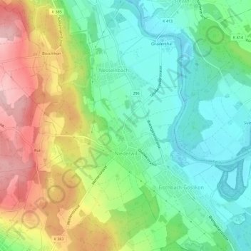
Name: Niederwil topographic map, elevation, terrain.
Location: Niederwil, Bezirk Bremgarten, Aargau, 5524, Switzerland (47.36157 8.27644 47.39951 8.30808)
Average elevation: 1,401 ft
Minimum elevation: 1,145 ft
Maximum elevation: 1,824 ft
Thank you for supporting this site ❤️
Make a donation
Make a donation
Gear up for your next adventure:
As an Amazon Associate, this site earns from qualifying purchases at no extra cost to you.