Geolocate

Evershot topographic map

Click on the map to display elevation.

About this map

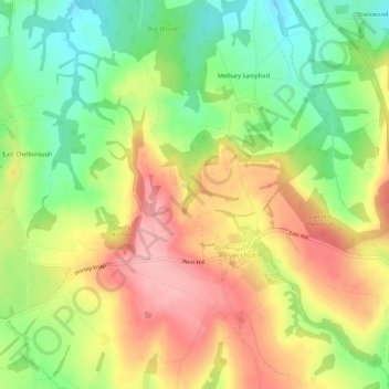
Name: Evershot topographic map, elevation, terrain.

Location: Evershot, Dorset, England, United Kingdom (50.82674 -2.63629 50.86151 -2.58029)

Average elevation: 512 ft

Minimum elevation: 292 ft

Maximum elevation: 738 ft

Other topographic maps

Click on a map to view its topography, its elevation and its terrain.

Morcombelake

United Kingdom > England > Dorset

Average elevation: 243 ft

Wareham

United Kingdom > England > Dorset

Average elevation: 52 ft

Fontmell Down

United Kingdom > England > Dorset > Fontmell Magna

Average elevation: 512 ft

Ridge

United Kingdom > England > Dorset > Wareham > Ridge

Average elevation: 23 ft

St Ives

United Kingdom > England > Dorset

Average elevation: 79 ft

Muckleford

United Kingdom > England > Dorset > Grimstone

Average elevation: 374 ft

Burning Cliff

United Kingdom > England > Dorset > South Holworth

Average elevation: 210 ft

Castletown

United Kingdom > England > Dorset

Average elevation: 59 ft

Mount Ararat

United Kingdom > England > Dorset > Verwood

Average elevation: 197 ft

Chiswell

United Kingdom > England > Dorset

Average elevation: 79 ft

Gear up for your next adventure:

🥩Freeze-Dried Meals - Nutritious and lightweight food for remote expeditions
Backpacking Tents - Weight-optimized shelters for multi-day topographic surveys
🧢Outdoor Hiking Hat - Sun protection hat for outdoor explorers
🪶Fire Starter Kit - Reliable fire starter for survival and camping
🧣Merino Neck Gaiters - Multi-functional headwear for wind and sun protection

As an Amazon Associate, this site earns from qualifying purchases at no extra cost to you.