
Make a donation
Gear up for your next adventure:
As an Amazon Associate, this site earns from qualifying purchases at no extra cost to you.
Kampung Melayu topographic map
Click on the map to display elevation.
Make a donation
Gear up for your next adventure:
As an Amazon Associate, this site earns from qualifying purchases at no extra cost to you.
About this map
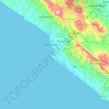
Name: Kampung Melayu topographic map, elevation, terrain.
Location: Kampung Melayu, Bengkulu, Sumatra, Indonesia (-4.62165 101.61289 -3.22165 103.01289)
Average elevation: 686 ft
Minimum elevation: -3 ft
Maximum elevation: 7,992 ft
Make a donation
Gear up for your next adventure:
As an Amazon Associate, this site earns from qualifying purchases at no extra cost to you.
Other topographic maps
Click on a map to view its topography, its elevation and its terrain.
Pulau Enggano
Indonesia > Bengkulu > Bengkulu Utara
Enggano is about 35 kilometres (22 miles) long from east to west and about 16 kilometres (9.9 miles) wide from north to south. Its area is 400.6 square kilometres (154.7 square miles) including four small offshore islands around its coast - Pulau Merbau, Pulau Dua and tiny Pulau Banggai off Enggano's east…
Average elevation: 62 ft