Geolocate

Vincennes topographic map

Click on the map to display elevation.

About this map

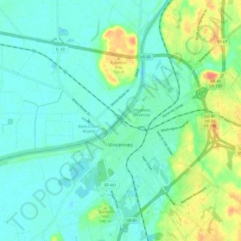
Name: Vincennes topographic map, elevation, terrain.

Location: Vincennes, Knox County, Indiana, 47591, United States (38.64459 -87.54919 38.72650 -87.46870)

Average elevation: 440 ft

Minimum elevation: 397 ft

Maximum elevation: 551 ft

Knox County trails, hiking, mountain biking, running and outdoor activities

Other topographic maps

Click on a map to view its topography, its elevation and its terrain.

Bunker Hill

United States > Indiana > Knox County > Vincennes

Average elevation: 420 ft

Gear up for your next adventure:

👟Trail Running Shoes - Lightweight shoes for trail runners
🥇GPS Hiking Watch - Multi‑sport GPS watch with navigation and trail tracking
🥤Water Filter Bottle - All‑in‑one filter bottle for safe hydration
🚪Portable Camp Chair - Foldable chair for comfort at camp
🦺Reflective Outdoor Gear - Safety gear for low‑light conditions

As an Amazon Associate, this site earns from qualifying purchases at no extra cost to you.