
Make a donation
Gear up for your next adventure:
As an Amazon Associate, this site earns from qualifying purchases at no extra cost to you.
Nelson topographic map
Click on the map to display elevation.
Make a donation
Gear up for your next adventure:
As an Amazon Associate, this site earns from qualifying purchases at no extra cost to you.
About this map
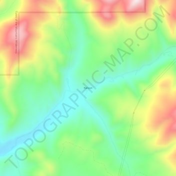
Name: Nelson topographic map, elevation, terrain.
Location: Nelson, Lewis and Clark County, Montana, United States (46.79688 -111.82915 46.83688 -111.78915)
Average elevation: 4,518 ft
Minimum elevation: 3,852 ft
Maximum elevation: 5,587 ft
Make a donation
Gear up for your next adventure:
As an Amazon Associate, this site earns from qualifying purchases at no extra cost to you.
Other topographic maps
Click on a map to view its topography, its elevation and its terrain.
Helena
United States > Montana > Lewis and Clark County
Helena is located at 46°35′45″N 112°1′37″W / 46.59583°N 112.02694°W / 46.59583; -112.02694 (46.595805, −112.027031), at an altitude of 4,058 feet (1,237 m).
Average elevation: 4,252 ft