
Thank you for supporting this site ❤️
Make a donation
Make a donation
Gear up for your next adventure:
As an Amazon Associate, this site earns from qualifying purchases at no extra cost to you.
Rigoso topographic map
Click on the map to display elevation.
Thank you for supporting this site ❤️
Make a donation
Make a donation
Gear up for your next adventure:
As an Amazon Associate, this site earns from qualifying purchases at no extra cost to you.
About this map
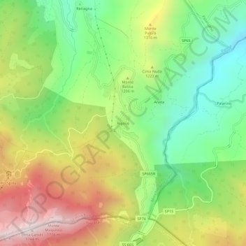
Name: Rigoso topographic map, elevation, terrain.
Location: Rigoso, Monchio delle Corti, Parma, Emilia-Romagna, Italia (44.34931 10.11653 44.38931 10.15653)
Average elevation: 3,757 ft
Minimum elevation: 2,392 ft
Maximum elevation: 5,614 ft
Thank you for supporting this site ❤️
Make a donation
Make a donation
Gear up for your next adventure:
As an Amazon Associate, this site earns from qualifying purchases at no extra cost to you.