Geolocate

ail topographic map

Interactive map

Click on the map to display elevation.

About this map

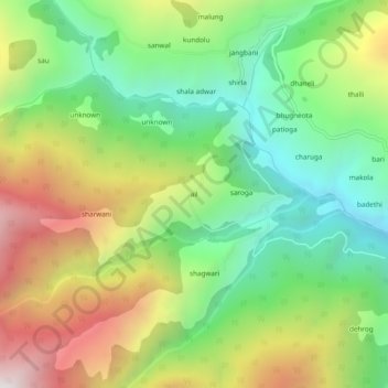
Name: ail topographic map, elevation, terrain.

Location: ail, Chaurah, Chamba District, Himachal Pradesh, India (32.81586 76.01592 32.85586 76.05592)

Average elevation: 6,864 ft

Minimum elevation: 4,892 ft

Maximum elevation: 9,793 ft

Other topographic maps

Click on a map to view its topography, its elevation and its terrain.

junu

India > Himachal Pradesh > Chaurah > Teesa

junu, Teesa, Chaurah, Chamba District, Himachal Pradesh, 176316, India

Average elevation: 6,263 ft

meas

India > Himachal Pradesh > Chaurah

meas, Chaurah, Chamba, Himachal Pradesh, India

Average elevation: 8,465 ft

suila

India > Himachal Pradesh > Chaurah > suila

suila, Chaurah, Chamba, Himachal Pradesh, India

Average elevation: 7,785 ft

Chilli

India > Himachal Pradesh > Chaurah

Chilli, Chaurah, Chamba, Himachal Pradesh, India

Average elevation: 5,105 ft