Geolocate

Barling topographic map

Click on the map to display elevation.

About this map

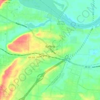
Name: Barling topographic map, elevation, terrain.

Location: Barling, Sebastian County, Arkansas, 72923, United States (35.30040 -94.32367 35.35486 -94.24268)

Average elevation: 446 ft

Minimum elevation: 367 ft

Maximum elevation: 604 ft

Sebastian County trails, hiking, mountain biking, running and outdoor activities

Other topographic maps

Click on a map to view its topography, its elevation and its terrain.

Fort Smith

United States > Arkansas > Sebastian County > Fort Smith

Average elevation: 535 ft

Old Jenny Lind

United States > Arkansas > Sebastian County

Average elevation: 551 ft

Gear up for your next adventure:

🔭Telescopic Hiking Pole - Adjustable pole for hiking stability
🌎3D Topographic Globes - Raised relief globes for a tactile understanding of geography
Solar GPS Watches - Advanced multisport watches with built-in topographic maps
🛶Inflatable Kayak - Portable kayak for rivers, lakes, and expeditions
🦶Hiking Gaiters - Keep debris and water out of your boots

As an Amazon Associate, this site earns from qualifying purchases at no extra cost to you.