
Make a donation
Gear up for your next adventure:
As an Amazon Associate, this site earns from qualifying purchases at no extra cost to you.
Gandra topographic map
Click on the map to display elevation.
Make a donation
Gear up for your next adventure:
As an Amazon Associate, this site earns from qualifying purchases at no extra cost to you.
About this map
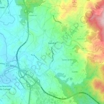
Name: Gandra topographic map, elevation, terrain.
Location: Gandra, Paredes, Porto, Portugal (41.17040 -8.45839 41.21459 -8.40418)
Average elevation: 584 ft
Minimum elevation: 302 ft
Maximum elevation: 1,257 ft
Make a donation
Gear up for your next adventure:
As an Amazon Associate, this site earns from qualifying purchases at no extra cost to you.
Other topographic maps
Click on a map to view its topography, its elevation and its terrain.
Make a donation
Gear up for your next adventure:
As an Amazon Associate, this site earns from qualifying purchases at no extra cost to you.
Make a donation
Gear up for your next adventure:
As an Amazon Associate, this site earns from qualifying purchases at no extra cost to you.
Santa Marinha do Zêzere
Portugal > Porto > Santa Marinha do Zêzere > Santa Marinha do Zêzere
Average elevation: 1,394 ft
Make a donation
Gear up for your next adventure:
As an Amazon Associate, this site earns from qualifying purchases at no extra cost to you.
Make a donation
Gear up for your next adventure:
As an Amazon Associate, this site earns from qualifying purchases at no extra cost to you.
Make a donation
Gear up for your next adventure:
As an Amazon Associate, this site earns from qualifying purchases at no extra cost to you.
São Tomé de Covelas
Portugal > Porto > Santa Cruz do Douro e São Tomé de Covelas
Average elevation: 1,168 ft