Geolocate

Paxos topographic map

Click on the map to display elevation.

Paxos

Paxos lies some 15 km from the southern tip of Corfu and at about the same distance from the town of Parga on the mainland. It is connected by ferry lines from Igoumenitsa and Corfu with Gaios. The island is hilly, the highest point having an elevation of 230 m.

Wikipedia (CC-BY-SA 3.0)

About this map

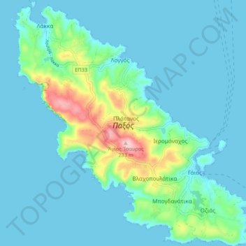
Name: Paxos topographic map, elevation, terrain.

Location: Paxos, Lakka, Municipality of Paxos, Corfu Regional Unit, Ioanian Islands, Peloponnese, Western Greece and the Ionian, 490 82, Greece (39.17809 20.12521 39.24107 20.20615)

Average elevation: 115 ft

Minimum elevation: -3 ft

Maximum elevation: 748 ft

Gear up for your next adventure:

📌Outdoor GPS Map App - Apps and devices for digital topographic navigation
🏥Hiking First Aid Kits - Comprehensive medical kits for remote trail injuries
🛠️Outdoor Gear Repair Kit - Essential tools to fix gear on the trail
🧭Pro Hiking Compasses - High-accuracy liquid-filled compasses for topographic orientation
🕶️GPS Smartphone Mount - Secure mount for phone navigation

As an Amazon Associate, this site earns from qualifying purchases at no extra cost to you.