
Make a donation
Gear up for your next adventure:
As an Amazon Associate, this site earns from qualifying purchases at no extra cost to you.
Kuala Krai topographic map
Click on the map to display elevation.
Make a donation
Gear up for your next adventure:
As an Amazon Associate, this site earns from qualifying purchases at no extra cost to you.
Kuala Krai
Kuala Krai (alternative spelling: Kuala Kerai, Jawi: كوالا كراي) is a town located in the coterminous Kuala Krai District in southern-central Kelantan, Malaysia. During British protection it was known as Kuala Lebir. It is 67 km from state capital Kota Bharu and 273 km from national capital Kuala Lumpur. The altitude is 53 metres (177 ft) above sea level here.
Make a donation
Gear up for your next adventure:
As an Amazon Associate, this site earns from qualifying purchases at no extra cost to you.
About this map
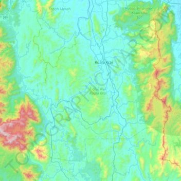
Name: Kuala Krai topographic map, elevation, terrain.
Location: Kuala Krai, Kelantan, Malaysia (5.17497 101.78719 5.68297 102.44178)
Average elevation: 817 ft
Minimum elevation: 26 ft
Maximum elevation: 5,653 ft
Make a donation
Gear up for your next adventure:
As an Amazon Associate, this site earns from qualifying purchases at no extra cost to you.
Other topographic maps
Click on a map to view its topography, its elevation and its terrain.