Geolocate

Turrialba topographic map

Click on the map to display elevation.

About this map

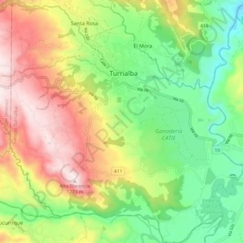
Name: Turrialba topographic map, elevation, terrain.

Location: Turrialba, Cantón Turrialba, Provincia Cartago, 30501, Costa Rica (9.84691 -83.72266 9.93256 -83.63904)

Average elevation: 2,513 ft

Minimum elevation: 1,414 ft

Maximum elevation: 4,016 ft

Other topographic maps

Click on a map to view its topography, its elevation and its terrain.

San Pablo

Costa Rica > Cantón Turrialba > Tres Equis

Average elevation: 2,425 ft

Paso Marcos

Costa Rica > Cantón Turrialba > Chirripó

Average elevation: 2,979 ft

Bajo Pacuare Norte

Costa Rica > Cantón Turrialba > Tuis

Average elevation: 2,247 ft

Aquiares

Costa Rica > Cantón Turrialba > Santa Rosa

Average elevation: 3,583 ft

Gear up for your next adventure:

🧥Men's Rain Shells - Premium waterproof and breathable jackets for mountain weather
🔭Telescopic Hiking Pole - Adjustable pole for hiking stability
🌧️Backpack Rain Cover - Keep gear dry in wet weather
🥄Camping Utensil Set - Lightweight utensils for outdoor meals
🧢Sun Protection Hats - Wide-brimmed and UPF-rated hats for high-altitude sun safety

As an Amazon Associate, this site earns from qualifying purchases at no extra cost to you.