Geolocate

Valderrama topographic map

Click on the map to display elevation.

About this map

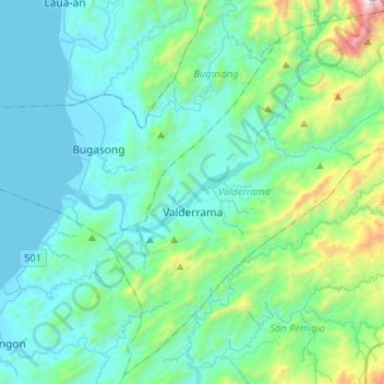
Name: Valderrama topographic map, elevation, terrain.

Location: Valderrama, Antique, Western Visayas, Philippines (10.89179 122.06876 11.13790 122.33238)

Average elevation: 971 ft

Minimum elevation: 0 ft

Maximum elevation: 6,286 ft

Other topographic maps

Click on a map to view its topography, its elevation and its terrain.

Agricula

Philippines > Antique > San Remigio

Average elevation: 1,227 ft

Poblacion

Philippines > Antique > Belison

Average elevation: 26 ft

Batbatan Island

Philippines > Antique > Culasi

Average elevation: 39 ft

Sibato Island

Philippines > Antique > Caluya

Average elevation: 7 ft

Tordesillas

Philippines > Antique > Sibalom > Tordesillas

Average elevation: 938 ft

Gear up for your next adventure:

🧷Carabiner Set - Durable clips for gear attachment
🎒Hydration Pack - Hands‑free water reservoir for long hikes
☀️Outdoor Sunscreen - High protection sunscreen for outdoor activities
🧭GPS Watch Accessories - Bands and chargers for GPS watches
🧭Pro Hiking Compasses - High-accuracy liquid-filled compasses for topographic orientation

As an Amazon Associate, this site earns from qualifying purchases at no extra cost to you.