Geolocate

Moorhead topographic map

Click on the map to display elevation.

About this map

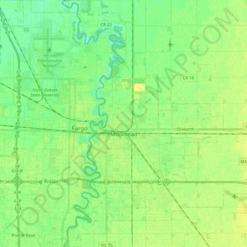
Name: Moorhead topographic map, elevation, terrain.

Location: Moorhead, Clay County, Minnesota, United States (46.81103 -96.80044 46.94860 -96.64777)

Average elevation: 909 ft

Minimum elevation: 879 ft

Maximum elevation: 935 ft

Clay County trails, hiking, mountain biking, running and outdoor activities

Other topographic maps

Click on a map to view its topography, its elevation and its terrain.

Ruthruff

United States > Minnesota > Clay County

Average elevation: 915 ft

Gear up for your next adventure:

📚USA Hiking Guide Books - Top trail guides and map books
🧭Outdoor Navigation Book - Learn advanced navigation skills
🧢Outdoor Hiking Hat - Sun protection hat for outdoor explorers
📖Nature Tracking Books - Learn to track wildlife and terrain
🌲Outdoor Survival Books - Best books on survival skills

As an Amazon Associate, this site earns from qualifying purchases at no extra cost to you.