
Taft topographic map
Click on the map to display elevation.
About this map
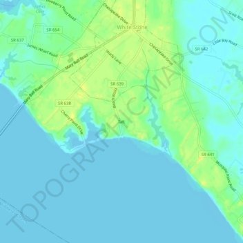
Name: Taft topographic map, elevation, terrain.
Location: Taft, Lancaster County, Virginia, 22578, United States (37.61285 -76.41135 37.65285 -76.37135)
Average elevation: 20 ft
Minimum elevation: -3 ft
Maximum elevation: 66 ft
Lancaster County trails, hiking, mountain biking, running and outdoor activities
Other topographic maps
Click on a map to view its topography, its elevation and its terrain.